In my last couple posts I mentioned a Saturday afternoon drive that ended in Hendersonville at the Blue Note Grill. When I first arrived at the Blue Note around 4:00, I was the only patron. So the bartender and I discussed kayaking and camping and fishing and gardening and miscellaneous other things. After awhile the owner of the Blue Note, David, showed up. I noticed that his signature waist length pony tail was missing. He said he felt he'd finally gotten too old for it. He poured a cup of coffee and then he and I spent a couple hours discussing music, food, craft beer, and the revitalization of Hendersonville. He showed me his new menu and asked for suggestions. We discussed how vinyl records are making a comeback. He mentioned his wife and kids. He was proud that his youngest only had a semester of college left. After his second cup of coffee, as if on cue, the bartender, Jim, poured him a Speckled Hen, clearly a ritual. Eventually other patrons arrived. A woman named Amanda. A Swedish fellow named Bo. Couples and groups of couples. Laura Blackley, host of Local Color on WNCW performed with the Swayback Sisters. As the house filled, Dave made the rounds and treated every patron the same way he always does, like we were all old friends.
Two days later David passed away in his sleep. There will be a celebration of his life this Sunday at the Blue Note. More details can be found here.
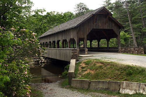
Campbell's Covered Bridge

There's a lot more information about it here.
Distance from downtown Greenville: 25 miles
View Larger Map
The Blue Note Grill

 I've previously mentioned that one of our favorite hangouts is the Back Room at the Flat Rock Wine Shoppe in Flat Rock, NC. Well they recently moved a few miles north to downtown Hendersonville into a great historic building. They have the same great menu and same extensive beer and wine list. (They're currently serving Highland's Cold Mountain Winter Ale on tap.) But they have a lot more room and best of all they have live music every night with no cover charge.
Distance from downtown Greenville: 39 miles
View Larger Map
TreesGreenville Turkey Day 8k 2010
 The last couple of weeks I've enjoyed helping to plant trees with an organization called TreesGreenville. This is one of several organizations I've discovered through the Hands on Greenville website. As the name implies, the organization plants trees in the area, mostly through the use of volunteers. It's run by a couple of really nice, knowledgeable, laid back people named Joelle and James. The first time I volunteered I learned a lot about how to properly plant a tree, which explains why I haven't always had such great luck in the past. I had similar learning experiences when I've helped plant vegetables at the Project Host Soup Kitchen garden and when I've done trail construction with the Sierra Club. So in addition to helping the community, there is a personal gain involved in these activities.
 On Thanksgiving Day TreesGreenville is hosting an 8K run at the ICAR facility as a fundraiser. So if you can run further than I can, and you need an excuse to get away from the extended family on Thanksgiving morning, you might want to check it out. You can sign up here.
DATE & TIME
Thursday, November 25th, 2010 -9am - Turkey Day 8k; 8:30am - 1/4 mile Toddler Trot. Please see the bottom of the page if interested in registering for the Tot Trot.
LOCATION
Hubbell Lighting within the CU-ICAR business park. Hubbell Lighting is located at 701 Millennium Blvd, Greenville, SC 29607.
View Larger Map
Rattlesnake Lodge


In the early 1900's a fellow by the name of Dr. Chase P. Ambler built a stone summer home for his family near Asheville. He sold it in the 1920's and unfortunately the lodge burned down a few years later. You can read the details here.
Some of the remains still exists. Reaching them can be a short uphill hike from the location below, or you can do a longer hike (16 miles round trip) by starting at the Craggy Garden parking area and taking the Mountains to Sea Trail east. This is a beautiful hike with great views.
View Larger Map
How to Get to the Blue Ridge Parkway from Greenville
 |
| Parkway in the distance as seen from Mountains to Sea Trail - Oct, 2008 |
The quickest and easiest is to take Hwy 25 to I26N to exit 37 and then follow the signs. It takes about an hour.
View Larger Map
If you're going north on the parkway you may want to keep going past that exit to I40E and take exit 44. That way you'll bypass the section that runs through Asheville which isn't that interesting (plus it's the only section I've ever seen anyone get pulled over for speeding on the Parkway - and yes I was the one pulled over).
View Larger Map
Another option is to go through Brevard via 276. That's a nicer drive but takes about an hour and a half. It puts you near the Pisgah Inn. An even nicer drive to get to this entrance would be to head up HWY 25 through Flat Rock.
View Larger Map
A fourth option if you want to get to a section further south is take 276 to Hwy 11 to Hwy 176 to Hwy 215. This puts you near the Middle Prong Wilderness and Shining Rock Wilderness, not far from the Devil's Court House.
View Larger Map
Fall for Greenville

There are dozens of other entertainment options at the festival as well.
Here's a little taste of Jason performing one of his songs live:
Distance from downtown Greenville: 0 Miles.
Waterrock Knob


Waterrock Knob is one of the highest points on the Blue Ridge Parkway. It's the 16th highest point east of the Mississippi. From the parking lot, it's a short but steep hike to the top. Even if you're not a hiker, it's worth the stop. Once while there I was standing above the clouds.
There are 40 peaks in the southern Appalachians over 6000 feet. There is a club designed to honor those who hike all of them. If you're inclined to do so you can reach several of them from this location.
 If you are a hiker and you're good with navigation and don't mind serious bushwhacking, you can have quite an adventure hiking to Mount Lyn Lowery, another 6000 footer where a 50' cross has been erected. There's also an amazing homesite for sale there, which would probably be the highest residential site on the east coast. To get there, when you get to the top of Waterrock, look to your left and you will see a faint little overgrown trail. Follow that trail a couple miles to Lyn Lowry and you'll have some great views along the way, assuming you don't get lost. Even if you do, you'll still have some great views. To say the trail is overgrown is an understatement. Below is a shot of one of the clearest parts of the trail. See that light green area, that's the trail. It gets much worse and you will get turned around and you will get cut up from all the blackberry bushes you have to trudge through. I ripped my pack and my pants.
You can find more details and download on-line maps here.
Distance from downtown Greenville: 98 miles

Greer Oktoberfest
See ya there: Greer Oktoberfest
SATURDAY, OCTOBER 2, 2010 12:00-9:00pm
DOWNTOWN GREER, SOUTH CAROLINA
Distance from downtown Greenville: 12 miles
View Larger Map
SATURDAY, OCTOBER 2, 2010 12:00-9:00pm
DOWNTOWN GREER, SOUTH CAROLINA
Entertainment for the day includes performances by the Channelheimer’s Oompah Band, Walhalla German Dancers, Dan Witucki’s Heimatland Musikanten, Al Ulle and the Dueling Slovenians, and the Foothills Oompah Band.
Traditional lederhosen and dirndl, the authentic dress, is encouraged for the event.
Festival goers should expect their mouths to melt from the array of German foods and desserts that will be served. Menu items include Bavarian white sausages, leberkaus, knackwurst, bratwursts, fresh baked pretzels, German funnel cakes, kettle korn, spaetzel, chipstix, glazed nuts, German chocolate cake, Black forest cake, and much more fantastic foods will be sold anywhere from $1 to $5.
Not only is the Greer Station Oktoberfest centered around German themes, it is embracing local artists and celebrating their creative works. Local artists will be displaying their creative pieces all day in downtown Greer. Work on display includes everything from oil paintings, ceramics, photography, woodwork, jewelry and much more. Festival organizers are encouraging people to come and support these artists and delight in each unique piece.
The official festival beer will be the “Spaten Oktoberfest,” which is the world’s first Oktoberfest beer, created in 1872 for the Munich Oktoberfest. It will be featured at two locations within the festival – the corner of Randall and Trade Street and the corner of Victoria and Trade Street. The festival will also have Thomas Creek, Budweiser and Pepsi products.
ENTERTAINMENT SCHEDULE
Main Stage12:00 - 4:00pm Channellheimer’s Oompah Band
5:00 - 9:00pm Foothills Oompah Band
Main Stage12:00 - 4:00pm Channellheimer’s Oompah Band
5:00 - 9:00pm Foothills Oompah Band
Beirgarten Stage
12:00 - 3:00pm All Ulle and the Deuling Slovenians
4:00 - 5:30pm Walhalla Oktoberfest Dancers
6:00 -9:00pm Dan Witucki and Heimatland Musikanten
12:00 - 3:00pm All Ulle and the Deuling Slovenians
4:00 - 5:30pm Walhalla Oktoberfest Dancers
6:00 -9:00pm Dan Witucki and Heimatland Musikanten
Distance from downtown Greenville: 12 miles
View Larger Map
Greenville - A good place to live
Fortune Magazine recently named Greenville as one of the top places to retire. This comes on the heels of a feature article on Greenville appearing in US Air's in-flight magazine. Meanwhile Charleston is named one of the Top American Towns in this month's addition of Outside Magazine and was recently named the number two vacation spot by Conde Nast. Asheville was recently named Beer City USA and (along with Brevard) was named one of the best cities to raise an outdoor kid by Backpacker Magazine. Considering that these places are all within a day's drive, Greenville seems like a pretty good place to live.
Otter Creek Water Park

Distance from downtown Greenville: 12 miles.
View Larger Map
Patriots Point

The Point is currently in dire need of federal support. Rep Jim Clyburn has introduced legislation to get the needed funds to keep the ships a float and open to the public. You can read more here.
Distance from downtown Greenville: 215 miles
View Larger Map
Bele Chere this Weekend

Bele Chere, the best street festival around takes place this weekend. While there you may want to check out the recently opened Lexington Avenue Brewery, a really cool, funky microbrewry or if you're in the mood for exquisitely good Italian food, try Cucina24 on Wall Street.
Distance from downtown Greenville: 63 miles.
View Larger Map
Flatrock Cinema

Distance from downtown Greenville: 35 miles
View Larger Map
Rocks and Ropes
Downtown Greenville is in dire need of a good rock climbing gym. At one time there were two, Urban Crags and Rocks and Ropes. Urban Crags closed down years ago and Rocks and Ropes has now moved from Main St. to the Blue Ridge area, but it is now open for business. Seems to me the new Ray Kroc Center would be a good place for a rock climbing gym (and a skate park).
Distance from downtown Greenville: 14 miles.
View Larger Map
Distance from downtown Greenville: 14 miles.
View Larger Map
Google on Main follow up
.png)

From the City of Greenville newsletter:
Saturday, March 20, 2010
7:30 PMMeet behind The Peace Center
Google is looking for one city around the country to invest billions of dollars in order to try out experimental ultra-high speed broadband internet. Come show your support for why they should select Greenville! The event will include thousands of people with LED-powered, Google-colored glow sticks walking in "fiber" lines into Falls Park and forming the letters "Google." Helicopters and national media will be filming the event from above. Let's make Greenville shine!
Click here to sign-up.
Distance from downtown Greenville: 0 miles.
View Larger Map
Linville Gorge
 Linville Gorge, called the Grand Canyon of North Carolina by some, is a rugged and remote area just off the Blue Ridge Parkway in Linville, NC. There are several trails that descend into the gorge to the Linville River. It's a truly amazing wilderness area but remember that if you make it to the river, you have to climb back out. The trails are rugged and rarely flat. See more here and here.
 |
| Swimming Hole at the junction of Babel Trail and Linville River. |
 |
| Top of Linville Falls |
 |
| Linville Falls |
 |
| Linvillle Falls up close. |


View Larger Map
Top of the Hops Beer Festival
Holy cow. Are you kidding me? Greenville is actually hosting a brewfest again? Yep. I've been pushing for a Greenville Beerfest ever since the two year old Greenville Beerfest closed shop several years ago. Now I see Greenville is hosting another beerfest. If you attend, make sure you spend time at my friend Tom's booth.
Click here for the details. Top of the Hops Beer Festival
Distance from downtown Greenville: 0 miles.
View Larger Map
Distance from downtown Greenville: 0 miles.
View Larger Map
Worley Cave


Worley Cave is a wild and relatively untouched cave located on a farm in Bluff City, TN. The owner of the cave allows exploration of the cave with a qualified guide.
Mountain Adventure Guides offers reasonable prices for qualified guides.
This isn't like Lurray Caverns. It's totally non-commercial. It is unspoiled and very deep. You will get very dirty, rip your clothes, climb, slide and be expected to walk through an underground river to exit the cave. You will also have a blast.
Distance from downtown Greenville: 161 miles.
View Larger Map
God's Plan

For some reason, I doubt the claim on the front of this Hummer.
St. Francis Mud Run
I got word back that registration is already closed for Art Loeb extreme hike I mentioned in the last post, but this sounds like a good time.
Extreme Hike for the Cure
I've mentioned a couple times previously one of my favorite trails, The Art Loeb.
Well this sounds kinda cool. Extreme Hike for the Cure
Well this sounds kinda cool. Extreme Hike for the Cure
| WHO: | All adventure and outdoor enthusiast | |
| WHAT: |  | |
| WHEN: | Friday, April 23—Sunday, April 25, 2010 |
| WHERE: | Art Loeb Trail Pisgah National Forest  | |
| WHY: | Through your participation in Extreme Hike for a Cure, you’ll experience adventure, accomplish a once in a lifetime goal, make new friends and add tomorrows to the lives of thousands of CF patients. | |
For more information or sponsorship opportunities contact Dede Brand at the Cystic Fibrosis Foundation at 704.321.7852 or dbrand@cff.org For more information on CF or the Cystic Fibrosis Foundation, visit www.cff.org. |
Disk (Frisbee) Golf Courses
Recently, one of my sons and I were trying to remember where all the good disk golf course are around here. These are the only ones we could remember.
Timmons Park - This a good one although it was recently re-routed and is a bit confusing toward the end.
Here are a couple more I found on-line that I'm not familiar with.
I'd love for people to chime in and offer others they know of, both in Greenville County and in the surrounding counties.
Update: Hat tip to Otis for the following resource. Upstate Disc Golf Courses
Update: Hat tip to Otis for the following resource. Upstate Disc Golf Courses
Mojitos Bar and Lounge

My wife and I had a very pleasant lunch at this West End restaurant recently. The place is owned by a Cuban entrepreneur who moved from Miami to open a business in Greenville. I'm no expert on Cuban food, but I can personally vouch for their Cuban sandwich.
Distance from downtown Greenville: 0 miles.
View Larger Map
Fernwood Nature Trail
The parks were packed last weekend with the spring weather. If you head down to Cleveland Park in the near future, be sure to take a stroll on the Fernwood Nature. The Sierra Club spent Saturday morning cleaning it up and adding mulch.
Distance from downtown Greenville: 0 miles.
View Larger Map
Distance from downtown Greenville: 0 miles.
View Larger Map
Japanese film series at Furman starts this week
 Japanese Film at Furman - Film Series
All films will begin at 6pm and will be followed by a short lecture.
The first 3 films will be shown in the Patrick Lecture hall in the Townes Science Center. The April 20th screening will be held in the Burgiss Theater in the Univ. Center.
All screenings are free and open to the public.
Feb. 2, 2010 - The Emperor's Naked Army Marches On
Mar. 2, 2010 - Departures
Mar. 30, 2010 - Dear Pyongyang
Apr. 20, 2010 - Ghose in the Shell: Mobile Armored Riot Police
Helping Haiti Rescue Efforts
No scam here. This is for real. If you'd like to donate to the relief efforts in Haiti you can do so by texting the word Haiti to 90999 from your mobile phone and you'll be billed $10. If you're suspicious you can check the following State Department site for confirmation (last paragraph).
http://www.state.gov/p/wha/ci/ha/index.htm
Slideshow of Haiti Destruction - Warning: Very Graphic
Indigo Blue Website
I don't do this very often but here is a new blog that seems like a good compliment to this one.
http://indigobluesc.com/
http://indigobluesc.com/
Kings Creek Falls

Just up the hill from the wild and scenic Chatooga River is Kings Creek Falls. This is a good one to catch on the way to Spoonauger Falls and Ellicott's Rock.
Park at the Burrells Ford Campground parking lot, then take the Foothills Trail, near the entrance to the parking area, to the falls. They're not hard to find. On the way back to Greenville, you might want to check out Isaqueena Falls and Stumphouse tunnel.
Distance from downtown Greenville: 66 miles.
View Larger Map
Subscribe to:
Posts (Atom)
