Showing posts with label Historic. Show all posts

Hurricane Tavern and Cashville Mercantile Store

I noticed this store today while driving back from Woodruff and when I got home decided to do a little research.

Turns out it dates back to 1920 and the home next to it was built in 1811. Apparently it was quite the place back in the day. It was a farm, tavern and store located on the stage coach road from Columbia to Asheville and from Anderson to Spartanburg. There were 18 homes on the site for the tenants and their families to live.

It still contains a number of structures on the property as well as a cotton gin but it's all very dilapidated.

There's quite a bit more I found out about the property on the National Registry of Historic places website.  Hurricane Tavern

There are more photographs here.

Cedar Falls Park


Looking for another place to run recently, I decided to check out Cedar Falls Park.  It's a pretty nice little park located on the Reedy River in Fork Shoals. There are plenty of trails to run or walk on and nice waterfalls. It's located on the site of an old saw mill and contains on old damn as well. 


Owings, SC


Recently my friend Tim and I stopped in at the tiny town of Owings, SC looking for interesting things to photograph. It's been at least 15 years since I've driven through the town.  It's as close to a ghost town as one might find nearby. And by ghost town, I don't mean dead town. It's actually being restored by a group called the Gray Court-Owings Historical Society


After perusing their website, I realized we missed some other interesting sites such as those found here.


Distance from downtown Greenville: 25 miles

Old Time Fiddlin' Convention @ Hagood Mill Today

Today from 11:00 - 4:00. See you there. 


"Hagood Mill, on the National Register of Historic Places, is a functioning 19th-century water powered gristmill. Benjamin Hagood, an early settler of the Carolina Upcountry, built the original mill c. 1825. His son, James Hagood, built the mill at its present location in 1845 and it continued operations until the 1960s. Under the watch of the Pickens County Museum, the mill continues to develop. Visitors are welcome during daylight hours to picnic and hike on the 13-acre tract. The mill is open for tours and corn-grinding demonstrations on the 3rd Saturday of every month and by appointment for large groups." from Discover South Carolina


Distance from downtown Greenville: 23 miles


View Larger Map


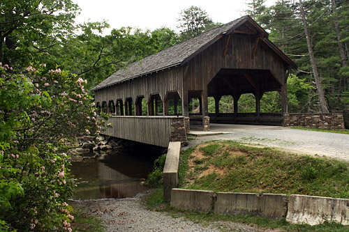
Campbell's Covered Bridge

So I unexpectedly found myself alone the other day, something I really needed, so I went for a drive, not really sure of where I'd end up.  Where I ended up can be seen in my last post, but the first stop I made was at Campbell's Covered Bridge.  I had never been there before, but people talk about it like it's something worth seeing. I guess if you're into bridges it's worth a stop and it's not far from Poinsett Bridge which I've blogged about previously.  Personally I think the covered bridge at Dupont State Forest is more interesting.

There's a lot more information about it here.


Distance from downtown Greenville: 25 miles


View Larger Map

Mabry Mill


Much like Hagood Mill, Mabry Mill is a step into the past. Located on the Blue Ridge Parkway in southwestern Virginia, the mill is open for tours. There are often volunteers on site working as blacksmiths, spinners, millers and demonstrating other 19th century occupations. On the weekends local bluegrass musicians stop by to play a mix of traditional tunes, folk and bluegrass music. A gift shop and restaurant are also located on the premises.

One of the things that I like about this particular mill is the intact and fully functional water flume that runs throughout the premises.


If you like old historic places like this but want something closer to home check out the Mountain Heritage Museum in Old Fort, NC, the aforementioned Hagood Mill in Pickens, the Cradle of Forestry in Brevard or the Roper Mountain Science Center here in Greenville.

Distance from downtown Greenville:231 miles.


View Larger Map

A Tailor's Lodging Bed and Breakfast

A Tailor's Lodging is located one block off Main Street in Abingdon, VA. The home was built in the 1840's by the town tailor. Although much of it has been updated, the owners have done an excellent job keeping it as authentic as possible. There are two rooms in the main house, one upstairs and one downstairs, and a large common area on the middle floor which includes a study, the kitchen, and a sitting room. The innkeepers, Rick and Susan, are very accommodating and generous, allowing guests free run of the place. They also offer great stories about the area.

An additional room is found in this cottage located next to the main house.

The house is one block from a bike rental/shuttle business and two blocks from the end of the Virginia Creeper Trail. The Martha Washington Inn is one block the other direction with the Barter Theatre located across the street. The Tavern is located about four blocks away and several other good restaurants are within walking distance.

Since Rick and Susan have regular jobs and don't live in the home, they don't offer a traditional breakfast. They will provide either a continental breakfast or a 10% discount for no breakfast. There is a great little place called the Trail Cafe one block away that offers some great breakfast options.

Distance from downtown Greenville: 172 miles.

Abingdon, VA

Abingdon, VA is a great little colonial town located in southwest Virginia. It's home to the Barter Theatre, a professional theatre house where many well known film actors got their start, including Gregory Peck, Ned Beatty and Ernest Borgnine.

As with any historic town, there are plenty of buildings rumored to be haunted. The most haunted (according to one local ghost hunter) is the Martha Washington Inn, a luxurious hotel located on Main Street.

Another location rumored to have ghosts galore is the oldest building in town, The Tavern. Built in 1789 it serves an upscale menu in a rustic environment. Be careful not to let your beer slide off the table though, as two centuries of settling have the left the building slightly less than level.

The next few posts will be related to the town of Abingdon. In the meantime, take a stroll down Main Street.


View Larger Map


Distance from downtown Greenville: 172 miles.


View Larger Map

Ellicott's Rock

The other day I was looking over one of my topo maps and I saw written in small text, "Ellicott Rock." So I think to myself, "That sounds like something. Maybe I should check it out." There are several ways to get to Ellicott's Rock, one of which is a four mile hike along the Chatooga River. Considering that the Chatooga is a beautiful river (and that the presence of banjo picking hillbillies is way overstated) that's the route I took. Along the way there were a couple of signs indicating I was indeed heading the right direction but nothing explaining what Ellicott's Rock is. I assumed I would find some sort of large boulder at the top of a knob with a cool view of the river. Well at one point, I looked at the time and realized I should be there at any moment but nothing indicated that I was climbing or that the terrain was about to lead me to something different. About two minutes later I arrived at a sign that said "Ellicot Rock." Oddly though, the sign pointed straight into the river. Puzzled, I ate lunch at a nearby campsite and headed home where my good pal Google was able to shed some light on the issue for me. (The image to the left above is not Ellicott's Rock. It's located on a side trail to Spoonauger falls.)

If I had done my research ahead of time, I would have discovered that Ellicot's Rock is the point at which North Carolina, Georgia and South Carolina converge. It was named after Andrew Ellicot a surveyor who was hired in 1811 to determine the border between Georgia and North Carolina. I'll let Wikipedia tell the rest of the story:

Two years later commissioners representing South Carolina and North Carolina marked a large rock along the the Chattooga River bank with the inscription "Lat 35 AD 1813 NC + S.C." as the juncture where the South Carolina and North Carolina state lines joined. The rock marked by the S.C. and N.C. commissioners in 1813, rather than the rock marked by Ellicott in 1811, is usually called Ellicott's Rock. This is commonly accepted as the point where the boundary lines of South Carolina, North Carolina, and Georgia join.

There are two versions in print on the distance between the two rocks. One is that Ellicott's original rock was 500 ft upstream.[1] In the other story, the rocks are much closer. De Hart's South Carolina Trails guide said that they are a "few feet apart."[2] In the North Carolina trail guide, he said Commissioner Rock is "ten feet downstream".[3]


This rock was listed in the National Register of Historic Places in 1973 and is located in Ellicott Rock Wilderness. The South Carolina Department of Archives and History has additional information,[4] and copies of the nomination forms.[5]


(Image from Wikipedia.)

Although I missed out on the destination, the journey was fantastic (and if given a choice between the two, that's how I prefer it).

Click here for an on-line trail map to Ellicott's Rock.


UPDATE: (9/8/09)

Return to Ellicott's Rock.  This past weekend I returned with my friends Tim and Nathan. We had trouble finding the "N G" pictured above but we do think we found the USGS benchmark on a boulder in the middle of the river.

ANOTHER UPDATE: Okay I finally found it, only because there was another guy there who showed me where to look. You have to jump down to the river and hang onto the rhodos while trying not to fall in to see the initials.


Distance from downtown Greenville to trailhead: 66 miles.


View Larger Map

Poinsett Bridge Heritage Preserve

This bridge, located in northern Greenville county, was built by Joel Poinsett in 1820. In addition to being one of the earliest settlers of Greenville, Poinsett also discovered the Poinsettia flower.

Supposedly the bridge is haunted by an old slave who was hung from it, a laborer who died building the bridge and by an indian tribe. Yet again, I witnessed no ghosts, but my wife's camera went dead as soon as she tried to photograph it. Hmmmm.....(Mine worked fine.)

Distance from downtown Greenville: 39 miles.


View Larger Map

Saturday Afternoon Ghost Hunting

After posting my trip to the haunted "children's" graveyard, I've continued to receive hits from others interested in the ghosts of the Carolinas. This has piqued my interest in the topic.

My pal Tom over at Random Connections, read my post then did his own investigation of the graveyard, posting a much more detailed analysis. (Tom and I have never actually met but we share a lot of the same interests.) Yesterday Tom posted a review about a new book by local author John Boyanoski titled More Ghosts of the Upstate. This is a sequal to his first book Ghosts of the Upstate. I picked up the sequel last night, not having read the original. Despite being a total skeptic (and a bit of a cynic) about such things, today I decided to go check out some of these so-called haunted sites for myself, partially using the book as a guide and in large part using the Google Earth KMZ file created by Tom.

It was an enlightening day. The creepiest location by far was the Alston/Honour House, primarily because the ghost of Aaron Burr's daughter who inhabits the residence appears to have really odd taste in landscaping and she apparently collects ice cream trucks as well. The top image is the site of the lynching of Willie Earle. He supposedly haunts the area, but I didn't see him.

The second image is from the Colony Theatre in Easley. I didn't see any ghosts there either but I did pick up Boyanoski's first book at a swanky little bookstore nearby. I didn't realize Easley had anything that was swanky, but across the street from the book store I also discovered a really nice little pizza joint.

In Abbeville I discovered the best evidence yet for the existence of ghosts. I didn't actually see any but Abbeville itself is a virtual ghost town. I've never understood what keeps it going. Practically everything was closed, which is typically the case when I'm there, and many buildings are vacant, yet somehow the town lives on. I had hoped to have a beer in the tavern located in the basement of the Belmont Inn (seen on the left) but it was closed...on a Saturday night. The Belmont is supposedly overrun with ghosts. Maybe they don't like to work on Saturday evenings.

From there I ventured over to the Abbewood Bed and Breakfast which supposedly has a ghost who was released after a hidden room in the inn was discovered. But it appeared to be a private residence so I wasn't able to enter it either. I also snapped a shot of the Abbeville Opera house which supposedly houses a mysterious patron who materializes in the upper balcony.

On second thought, maybe the dozen or so people I saw walking around the square in Abbeville were all spirits from beyond.  Wow, they looked so real, well except for one guy.

By far the most interesting place I explored was the Fox & Hound Pub located in the Inn on the Square in Greenwood. I was pleased to find that this pub had a great atmosphere with paneled walls, leather chairs, good food and a full bar. According to Boyanoski's latest book, the inn is haunted by Bill, a real prankster. Unlike most ghosts, Bill doesn't know how to walk through walls so sometimes he gets locked in the pub causing him to bang on the doors. Rumor has it that Bill likes to tap newcomers on the shoulder and watch them jump, so I was a bit disappointed that by the time I finished my dinner Bill had not bothered to introduce himself to me. Turning to leave though I discovered the most chilling sight of my day. Before me, larger than life, was solid evidence that things were oddly amiss in this dark little pub. A strange glow was coming from one of the pub walls. I started to dismiss it as the work of an overactive imagination, but as I looked closer I could not deny what I saw coming from the glowing object. Flordia 30 - Tennessee 6.  If strange things were not afoot in that little bar then someone please explain to me how a washed up team like UT managed to score against the Gators.

I must admit, I'm now a little less skeptical.

Distance from downtown Greenville:
1-60 miles.

Patriots Point

Image above taken from Patriots Point website.

Patriots Point, located in Mt. Pleasant, SC, is the location of four retired military vessels - the USS Yorktown, an aircraft carrier; the USS Laffey, a destroyer; the USS Clamagore, a submarine; and the USCG Cutter Ingham, a Coast Guard Cutter. All four vessels are open for a self-guided tour. Climbing aboard these ships makes it immediately apparent that our men and women in the armed forces make many sacrifices even during peacetime.

The USS Yorktown houses an air and naval museum which includes both replicas and real aircraft from past decades. There is a snack bar onboard as well but be sure to bring cash, especially in the summer months, as it gets very hot aboard these vessels.


View Larger Map
Location: 32°47'24.40"N 79°54'29.63"W
Distance from downtown Greenville: 215 miles
Local Geocaches


Fort Moultrie

Located on Sullivan's Island, SC Fort Moultrie was a major stronghold for the American patriots in their defense against the British as well as for the Confederates in their defense against the Union.

The fort is open for tours and, as part of the National Park system, the entry fee is very reasonable.

From Fort Moultrie, Fort Sumter can be seen. Fort Sumter is accessible only by ferry and is a bit more expensive to access, although worth the visit as well.

Location: 32°45'36.84"N 79°50'25.15"W
Distance from downtown Greenville: 220 miles
Local Geocaches


King's Mountain National and State Parks

Kings Mountain National Military Park is the site of a revolutionary war battle where the American Patriots turned the tide against the Tories. A short paved path through the battlefield takes the visitors through a nicely wooded area with various stops along the way explaining the history of the park.

This Memorial Day weekend reenactors were on site offering demonstrations.

Beside King's Mountain National Park, lies King's Mountain State Park. The state park has a nice little campground, hiking and horseback riding trails and a couple of small lakes.

Location: N 35° 08.466 W 081° 22.592
Distance from downtown Greenville: 69 miles
Local Geocaches


Charles Towne Landing


Charles Town Landing is a great way to spend a couple of hours. The park is located on the original Charles Towne settlement site.


A paved walking path will take you past indian burial grounds, a reproduction of a 17th century trading ship, an experimental garden and through a zoo featuring animals indigenous to 17th century South Carolina.


On-going archelogical digs are located throughout the property.

Otters, bison, black bears, pumas, turkeys and several other animals are located in the animal park.


Location: 32°48'34.23"N 79°59'44.04"W
Distance from downtown Greenville: 210 miles
Local Geocaches


Magnolia Plantation and Gardens


Magnolia Plantation is located northwest of Charleston. The plantation features walking gardens and a petting zoo with peacocks, deer & Shetland ponies.


A swamp on the property can be toured via a boardwalk that meanders throughout.


The swamp is loaded with wildlife including egrets, blue and green herons, turtles and alligators. The alligators here are smaller and typically at a safer distance than those on Bull Island. The largest we saw was only about four feet long, compared to the 12-14 foot long alligators on Bull Island.

Location: 32°52'10.05"N 80° 5'18.43"W
Distance from downtown Greenville: 213 miles
Local Geocaches